Kind of Special Facilities Σ
No unique allocation. Some kind of special facilities are more specified with tags in details.
-
-
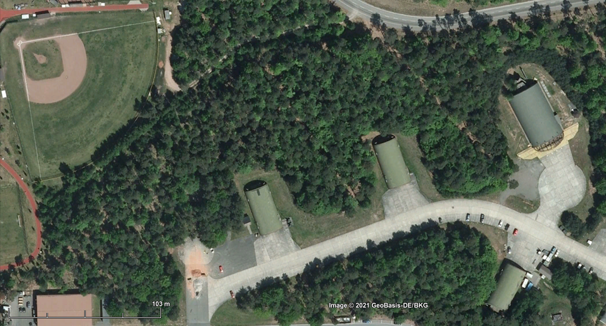
DEU | Mannheim: Coleman Worksite
 https://www.openstreetbrowser.org/#map=15/49.5611/8.4662&categories=military
49.56, 8.47
https://www.openstreetbrowser.org/#map=15/49.5611/8.4662&categories=military
49.56, 8.47
Google Earth 2021 Wikipedia EN: https://en.wikipedia.org/wiki/Coleman_Army_Airfield
DE: https://de.wikipedia.org/wiki/Coleman_BarracksNote: temporary closed but since 2015 used again for logistical purpose.
Declared as APS-2 (Army Propositioned Stock Europe)
More info: https://www.europeafrica.army.mil/Portals/19/documents/Fact%20Sheets/APS%20Fact%20Sheet%2011202020.pdf -
DEU | Büchel NATO Air Base
https://www.openstreetbrowser.org/#map=13/50.1746/7.0548&categories=military
50.176389, 7.057778
Google Earth 2021 Wikipedia EN: https://en.wikipedia.org/wiki/B%C3%BCchel_Air_Base
DE: https://de.wikipedia.org/wiki/Fliegerhorst_B%C3%BCchel
Nuclear sharing EN: https://en.wikipedia.org/wiki/Nuclear_sharing
DE: https://de.wikipedia.org/wiki/Nukleare_TeilhabeCampaign info: https://atomwaffenfrei.de

-
-
. Unspecific Location / Site | .. Airplane Landing Site | .. Use of Civil Naval Port | Europe | North Europe
N | Trondheim
https://www.openstreetbrowser.org/#map=12/63.4344/10.3659&categories=military
63.43, 10.36
click for full size Wikipedia EN: https://en.wikipedia.org/wiki/Trondheim_Airport,_V%C3%A6rnes
-
DJI | Camp Lemonnier
https://www.openstreetbrowser.org/#map=15/11.5413/43.1626&categories=military
11.543611, 43.148611
Google Earth 2021 
Google Earth 2011 Wikipedia EN: https://en.wikipedia.org/wiki/Camp_Lemonnier
-
NE | Air Base 201, Agadez
https://www.openstreetbrowser.org/#map=14/16.9497/8.0288&categories=military
16.94910, 8.01356
Google Earth 2017 
Google Earth 2021 Wikipedia EN: https://en.wikipedia.org/wiki/Agadez_Region
DE: https://de.wikipedia.org/wiki/Agadez#Verkehr -
-
DEU | Kaiserslautern: Pulaski Barracks
https://www.openstreetbrowser.org/#map=15/49.4285/7.6930&categories=military
49.430, 7.687
Wikipedia EN: n/a
BSR entries (3): Pulaski Barracks – Einsiedlerkoepfe Training Annex – Vogelweh Family Housing Annex
-
DEU | Ramstein: Distributed Command Ground System
https://www.openstreetbrowser.org/#map=19/49.44620/7.61247&categories=military
49.446193,  7.611922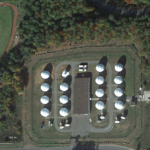
Google Earth 2017 
Google Earth 2010 belongs to: Ramstein Air Base
Wikipedia EN: https://en.wikipedia.org/wiki/Brandon_Bryant_(whistleblower)
-
DEU | Kaiserslautern: Rhine Ordnance Barracks Vogelweh
https://www.openstreetbrowser.org/#map=15/49.4447/7.6931&categories=military
 49.444002,  7.698268
Wikipedia EN: n/a
Included: Rhine Ordnance Training Area
-
DEU | Ramstein: EIAMDC European Integrated Air and Missile Defence Center
https://www.openstreetbrowser.org/#map=19/49.42907/7.65706&categories=military
 49.429072,  7.656961

Google Earth 2017 Wikipedia EN: https://en.wikipedia.org/wiki/Allied_Air_Command
DE: https://de.wikipedia.org/wiki/Allied_Air_CommandOfficial Source: https://ac.nato.int/
Belongs to: Ramstein Air Base
-
DEU | Kaiserslautern: Kapaun Air Station
https://www.openstreetbrowser.org/#map=15/49.4300/7.7127&categories=military
 49.428913,  7.697288
Wikipedia EN: n/a
BSR entry: Kapaun Administration Annex
Note:
“The 3rd Space Communications Squadron, located at Kapaun Air Force Station, Germany, provides vital communication support for U.S. and allied forces. ..
The mission of the 3rd SCS is to provide critical defense communications data to other wing units, as well as to the North American Aerospace Defense Command and United States Space Command at Cheyenne Mountain Air Force Station, Colo; United States Strategic Command at Offutt Air Force Base, NE; and the National and Alternate Military Command Centers.
The 3rd SCS provides critical and timely communications capabilities to the national command authorities and unified and theater commanders. It also plays a key role in giving field commanders the communications and information needed to fight and win theater conflicts.”
Source: https://www.globalsecurity.org/space/agency/3scs.htm