
App 3: OpenStreetBrowser
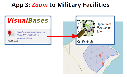
Single Views with Links from VisualBases
All locations in VisualBases have a complete Link to OpenStreetBrowser with the military layer.
Further option: With a copy and paste of the additional coordinates a direct access to the location in Google Maps or Google Earth is possible.
Note: Coordinates within the OpenStreetBrowser are normally slightly different from the copy&paste coordinates. because the first one refer to the display on a typically 1200 x 800 PC screen and the latter are normally pasted from a single place within the location.
Basics about OpenStreetBrowser
Openstreetbrowser.org is a cooperation of OpenStreetMap and Wikimedia (Commons, Wikipedia, Wikidata, …). OpenStreetMap objects are linked to Wikimedia objects with tags and optional layer like among others “Infrastructure → Military”.
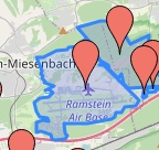
Military tags are visible step by step with zoom factor.
Zoom factor 11: tags of main locations visible
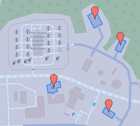
Zoom factor 14: tags of facilities visible
Beginning with zoom level 14 in Openstreetbrowser you can see many facilities, mostly unnamed.
Note: Not all special facilities by definition in Visualbases must have a corresponding military object pin in Openstreetbrowser.
Example with Internet Link
15: Zoom factor
15/49.4369/7.6027: Decimal coordinates (Lat./Lon. – WGS84)
OpenStreetMap link: https://www.openstreetmap.org/#map=15/49.4369/7.6027
same link in OpenStreetbrowser with layer “Military”
https://www.openstreetbrowser.org/#map=15/49.4369/7.6027&categories=military
Examples with OpenStreetBrowser Maps
Code of Military Layer in OpenStreetBrowser
“query”: {
“11”: [
“(“,
“node[military~\”^(airfield|danger_area)$\”];”,
“node[landuse=military];”,
“way[military~\”^(airfield|danger_area)$\”];”,
“way[landuse=military];”,
“relation[military~\”^(airfield|danger_area)$\”];”,
“relation[landuse=military];”,
“)”
],
“14”: [
“(“,
“node[military];”,
“node[landuse=military];”,
“way[military];”,
“way[landuse=military];”,
“relation[military];”,
“relation[landuse=military];”,
“)”